In recent years, fire accidents in key units of urban fire safety have occurred frequently, and the shortage of fire emergency rescue technology and equipment has undoubtedly increased the loss of accidents.
On August 12, 2015, an explosion occurred in the dangerous goods warehouse of Ruihai International Logistics Co., Ltd. in Tianjin Binhai New Area. The explosion caused a total of 165 people to die, 8 people were missing, 798 people were injured, and the direct economic loss was 6.866 billion yuan, of which 110 people were injured or injured. In the process of fire fighting and rescue, the commander failed to obtain the type and quantity of the fire substance and its surrounding dangerous goods quickly and accurately, which made it difficult to make a correct risk prediction for the fire. In the absence of any warning, two big explosions occurred in a short period of time, causing heavy losses to the rescue forces. On April 22, 2016, a fire broke out at the No. 2 exchange station in the storage tank area of ​​Jiangsu Deqiao Warehousing Co., Ltd., and one fire fighter died. The direct economic loss was 2,532,400 yuan. During the fire-fighting process, the fire commander failed to accurately predict the dangerous area of ​​the fire, resulting in a public security fire fighter who was killed in the fire-fighting rescue process. The above accidents have exposed the shortcomings in the field of fire emergency rescue in China: the existing emergency rescue technology and equipment can no longer meet the needs of large-scale fire accident rescue. At present, China's fire emergency rescue technology and equipment have the following problems:
The disaster site information is limited to two-dimensional planarization, and the basic information of the fire department unit fire includes serious missing information such as personnel information and drawings. When the disaster occurred, it was difficult for the fire department to fully understand the three-dimensional basic information of the disaster area in a short period of time, thus greatly reducing the efficiency of fire fighting and rescue. The existing single two-dimensional planarized fire information has even worsened the loss of golden time for rescue.
The rescue personnel's ability to detect disasters in the fire field is weak, and the means of detecting fire information is scarce. The disaster information including the temperature field distribution around the fire site and the concentration of toxic and harmful gases is almost unknown, and there is a great hidden danger in the rescue process. Information transmission is difficult, and the development of offensive routes, fire-fighting techniques, and personnel deployment plans during the disaster relief process is lagging. It is impossible to update the disaster-changing information in a timely manner, and the rescue efficiency is greatly reduced.
The fire commander's combat command relies on experience and lacks scientific basis. At present, firefighting forces rely heavily on the personal combat experience of firefighting commanders in terms of power deployment, offensive direction, and choice of fire fighting technology. Personal combat experience is accumulated in limited rescue operations, and there are occasional and unscientific, and Due to time, cost and other conditions, fire-prevention drills cannot be carried out on a large number of key fire units, which limits the operational level of fire commanders.
General Secretary Xi said in the National Security Working Group meeting that it is necessary to strengthen the safety production management in key areas such as fire protection and hazardous chemicals. It is necessary to increase the capacity building for the protection of materials, technologies, equipment, talents, laws, and mechanisms needed to maintain national security, and better adapt to the needs of national security work. The Central Committee of the Communist Party of China, the State Council, and the Central Military Commission have also issued several documents requesting the strengthening of emergency rescue forces and funding for the development of emergency rescue technologies.
In order to enable fire rescue personnel to obtain the basic conditions of the building accurately and effectively, timely develop a reliable emergency rescue plan, improve the operational command level of the fire commander and the firefighting and rescue capability of the fire brigade, and minimize the casualties and property losses caused by the fire. There is an urgent need to build a three-dimensional visual emergency rescue system, so this work, based on GIS and drone three-dimensional intelligent fire emergency rescue system.
Based on UAV technology , GIS 3D modeling technology, fire dynamics model and fire fighting theory, this system has developed a 3D intelligent fire emergency rescue system. It can realize rapid three-dimensional modeling of urban buildings (structures) and comprehensive real-time detection of fire disaster information. At the same time, the system also added modules such as plan drills and sand table deductions, which can assist rescue command and decision-makers to develop a set of targeted fire fighting and rescue strategies with high efficiency and high safety factor to improve the fire fighting effectiveness of fire brigades. Safeguard the safety of people and firefighters in the fire.
The team took the fire safety key unit as the research object, and designed a new fire emergency rescue system to solve the problem of lack of fire information, insufficient detection of disaster information, and lack of scientific basis for command decision. The system is based on the GIS three-dimensional model of the building (structure), with the fire model and fire fighting theory as the main body, and docked the UAV monitoring information and the control room Internet of Things, realizing the access to the police, the police, the fire field information, The auxiliary functions of command decision-making and power deployment have promoted the development of intelligent emergency rescue.
The system is based on three-dimensional GIS modeling technology, drone technology, fire dynamics model, emergency rescue theory and other advanced technologies, developed a set of three-dimensional intelligent fire emergency rescue system. The overall idea of ​​the system is as follows:
(1) Realize the three-dimensional visualization of key units of urban fire safety. The introduction of geographic information system (GIS) 3D modeling technology, the rapid and effective coverage of surface objects and feature points by the tilt camera, and the post-processing 3D modeling technology based on the graphics unit GPU, fast, simple and complete Automated 3D modeling establishes a 3D model of urban firefighting areas and fire protection key units, and enables fast and direct measurement of 3D models.
(2) Construct a real-time monitoring system for disaster sites. Realize the docking of real-time monitoring information of fire control room, including video monitoring information, fire linkage alarm information, water fire extinguishing system equipment information; real-time transmission of drone information collected by drones, including temperature distribution information of fire field, concentration distribution information of toxic and harmful gases .
(3) Set up a controllable virtual fire model and disaster relief model. Develop sandbox drills and pre-planning function modules, and build a three-dimensional package module for people and vehicles, which can be used for both wartime command and regular exercise. The 3D virtual fire model was developed based on the fire dynamics model and 3D technology. According to the fire rescue theory and the three-dimensional virtual fire model intelligently defined the scope of the dangerous area, realize the scientific and rational deployment of rescue forces, so that fire rescue can be based on evidence.
Based on the above ideas, the system structure and basic principles are proposed, as shown in the following figure:
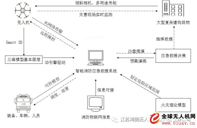
(1) The drone is equipped with a tilt camera to take high-definition shots of large buildings (structures), and the high-definition pictures are imported into the 3D model basic layer file that can be called by the Smart 3D generation software. The layer file is imported into the software, and the 3D model is used to realize the 3D roaming of the 3D model in the software.
(2) The drone is equipped with a toxic and harmful gas analyzer and a three-light pod to monitor the ground disaster site. Real-time data collection of high-definition images, infrared thermal imaging, and toxic and harmful gas concentrations at the disaster site are transmitted to the ground server in real time through a 4G network for real-time retrieval by users.
(3) Design the human-car three-dimensional packaging module to receive location information and status information in real time. Defining the layout of disaster relief forces and real-time scheduling and deployment of human and vehicle equipment.
(4) The emergency rescue software docks the information of the fire control room on the scene of the accident, and realizes the real-time reception of fire-fighting Internet of Things information such as video surveillance information, linkage alarm information and active fire-fighting equipment information.
(5) Develop a fire theory model into software code. Using the classical pool fire model Thomas empirical formula, ignition source calculation method and Mudan calculation method, the program for determining the safety distance of the personnel and the dangerous range of the tank area is prepared, and the three-dimensional display of the fire theory model in the software is realized. The fire rescue theory of the oil irrigation plant area is embedded in the system. According to the scope of the defined dangers, scientifically deploy rescue forces to assist in the formulation of rescue decisions.
(6) The emergency rescue software nests the entire set of scientific rescue processes. The software will transform the series of scientific rescue decision-making processes into functional modules from the control room alarm, fire brigade alarm, fire alarm, fire information acquisition, fire rescue power deployment, assist the firefighters to carry out each step of rescue work, provide command convenience, improve combat ability.
For detailed fire drone solutions, please call:
Manager Wang
Manager Liu
Manager Yang
On August 12, 2015, an explosion occurred in the dangerous goods warehouse of Ruihai International Logistics Co., Ltd. in Tianjin Binhai New Area. The explosion caused a total of 165 people to die, 8 people were missing, 798 people were injured, and the direct economic loss was 6.866 billion yuan, of which 110 people were injured or injured. In the process of fire fighting and rescue, the commander failed to obtain the type and quantity of the fire substance and its surrounding dangerous goods quickly and accurately, which made it difficult to make a correct risk prediction for the fire. In the absence of any warning, two big explosions occurred in a short period of time, causing heavy losses to the rescue forces. On April 22, 2016, a fire broke out at the No. 2 exchange station in the storage tank area of ​​Jiangsu Deqiao Warehousing Co., Ltd., and one fire fighter died. The direct economic loss was 2,532,400 yuan. During the fire-fighting process, the fire commander failed to accurately predict the dangerous area of ​​the fire, resulting in a public security fire fighter who was killed in the fire-fighting rescue process. The above accidents have exposed the shortcomings in the field of fire emergency rescue in China: the existing emergency rescue technology and equipment can no longer meet the needs of large-scale fire accident rescue. At present, China's fire emergency rescue technology and equipment have the following problems:
The disaster site information is limited to two-dimensional planarization, and the basic information of the fire department unit fire includes serious missing information such as personnel information and drawings. When the disaster occurred, it was difficult for the fire department to fully understand the three-dimensional basic information of the disaster area in a short period of time, thus greatly reducing the efficiency of fire fighting and rescue. The existing single two-dimensional planarized fire information has even worsened the loss of golden time for rescue.
The rescue personnel's ability to detect disasters in the fire field is weak, and the means of detecting fire information is scarce. The disaster information including the temperature field distribution around the fire site and the concentration of toxic and harmful gases is almost unknown, and there is a great hidden danger in the rescue process. Information transmission is difficult, and the development of offensive routes, fire-fighting techniques, and personnel deployment plans during the disaster relief process is lagging. It is impossible to update the disaster-changing information in a timely manner, and the rescue efficiency is greatly reduced.
The fire commander's combat command relies on experience and lacks scientific basis. At present, firefighting forces rely heavily on the personal combat experience of firefighting commanders in terms of power deployment, offensive direction, and choice of fire fighting technology. Personal combat experience is accumulated in limited rescue operations, and there are occasional and unscientific, and Due to time, cost and other conditions, fire-prevention drills cannot be carried out on a large number of key fire units, which limits the operational level of fire commanders.
General Secretary Xi said in the National Security Working Group meeting that it is necessary to strengthen the safety production management in key areas such as fire protection and hazardous chemicals. It is necessary to increase the capacity building for the protection of materials, technologies, equipment, talents, laws, and mechanisms needed to maintain national security, and better adapt to the needs of national security work. The Central Committee of the Communist Party of China, the State Council, and the Central Military Commission have also issued several documents requesting the strengthening of emergency rescue forces and funding for the development of emergency rescue technologies.
In order to enable fire rescue personnel to obtain the basic conditions of the building accurately and effectively, timely develop a reliable emergency rescue plan, improve the operational command level of the fire commander and the firefighting and rescue capability of the fire brigade, and minimize the casualties and property losses caused by the fire. There is an urgent need to build a three-dimensional visual emergency rescue system, so this work, based on GIS and drone three-dimensional intelligent fire emergency rescue system.
Based on UAV technology , GIS 3D modeling technology, fire dynamics model and fire fighting theory, this system has developed a 3D intelligent fire emergency rescue system. It can realize rapid three-dimensional modeling of urban buildings (structures) and comprehensive real-time detection of fire disaster information. At the same time, the system also added modules such as plan drills and sand table deductions, which can assist rescue command and decision-makers to develop a set of targeted fire fighting and rescue strategies with high efficiency and high safety factor to improve the fire fighting effectiveness of fire brigades. Safeguard the safety of people and firefighters in the fire.
The team took the fire safety key unit as the research object, and designed a new fire emergency rescue system to solve the problem of lack of fire information, insufficient detection of disaster information, and lack of scientific basis for command decision. The system is based on the GIS three-dimensional model of the building (structure), with the fire model and fire fighting theory as the main body, and docked the UAV monitoring information and the control room Internet of Things, realizing the access to the police, the police, the fire field information, The auxiliary functions of command decision-making and power deployment have promoted the development of intelligent emergency rescue.
The system is based on three-dimensional GIS modeling technology, drone technology, fire dynamics model, emergency rescue theory and other advanced technologies, developed a set of three-dimensional intelligent fire emergency rescue system. The overall idea of ​​the system is as follows:
(1) Realize the three-dimensional visualization of key units of urban fire safety. The introduction of geographic information system (GIS) 3D modeling technology, the rapid and effective coverage of surface objects and feature points by the tilt camera, and the post-processing 3D modeling technology based on the graphics unit GPU, fast, simple and complete Automated 3D modeling establishes a 3D model of urban firefighting areas and fire protection key units, and enables fast and direct measurement of 3D models.
(2) Construct a real-time monitoring system for disaster sites. Realize the docking of real-time monitoring information of fire control room, including video monitoring information, fire linkage alarm information, water fire extinguishing system equipment information; real-time transmission of drone information collected by drones, including temperature distribution information of fire field, concentration distribution information of toxic and harmful gases .
(3) Set up a controllable virtual fire model and disaster relief model. Develop sandbox drills and pre-planning function modules, and build a three-dimensional package module for people and vehicles, which can be used for both wartime command and regular exercise. The 3D virtual fire model was developed based on the fire dynamics model and 3D technology. According to the fire rescue theory and the three-dimensional virtual fire model intelligently defined the scope of the dangerous area, realize the scientific and rational deployment of rescue forces, so that fire rescue can be based on evidence.
Based on the above ideas, the system structure and basic principles are proposed, as shown in the following figure:
(1) The drone is equipped with a tilt camera to take high-definition shots of large buildings (structures), and the high-definition pictures are imported into the 3D model basic layer file that can be called by the Smart 3D generation software. The layer file is imported into the software, and the 3D model is used to realize the 3D roaming of the 3D model in the software.
(2) The drone is equipped with a toxic and harmful gas analyzer and a three-light pod to monitor the ground disaster site. Real-time data collection of high-definition images, infrared thermal imaging, and toxic and harmful gas concentrations at the disaster site are transmitted to the ground server in real time through a 4G network for real-time retrieval by users.
(3) Design the human-car three-dimensional packaging module to receive location information and status information in real time. Defining the layout of disaster relief forces and real-time scheduling and deployment of human and vehicle equipment.
(4) The emergency rescue software docks the information of the fire control room on the scene of the accident, and realizes the real-time reception of fire-fighting Internet of Things information such as video surveillance information, linkage alarm information and active fire-fighting equipment information.
(5) Develop a fire theory model into software code. Using the classical pool fire model Thomas empirical formula, ignition source calculation method and Mudan calculation method, the program for determining the safety distance of the personnel and the dangerous range of the tank area is prepared, and the three-dimensional display of the fire theory model in the software is realized. The fire rescue theory of the oil irrigation plant area is embedded in the system. According to the scope of the defined dangers, scientifically deploy rescue forces to assist in the formulation of rescue decisions.
(6) The emergency rescue software nests the entire set of scientific rescue processes. The software will transform the series of scientific rescue decision-making processes into functional modules from the control room alarm, fire brigade alarm, fire alarm, fire information acquisition, fire rescue power deployment, assist the firefighters to carry out each step of rescue work, provide command convenience, improve combat ability.
For detailed fire drone solutions, please call:
Manager Wang
Manager Liu
Manager Yang
Draw-wire sensors of the wire sensor series measure with high linearity across the entire measuring range and are used for distance and position measurements of 100mm up to 20,000mm. Draw-wire sensors from LANDER are ideal for integration and subsequent assembly in serial OEM applications, e.g., in medical devices, lifts, conveyors and automotive engineering.
Linear Encoder,Digital Linear Encoder,Draw Wire Sensor,1500Mm Linear Encoder
Jilin Lander Intelligent Technology Co., Ltd , https://www.jllandertech.com