First, the introduction
Unmanned Aerial Vehicle (UAV) is an unmanned aircraft that is powered, controllable, capable of carrying multiple missions, performing multiple tasks, and being reusable. The combination of UAV and remote sensing technology, that is, UAV remote sensing, is the use of advanced unmanned aerial vehicle technology, remote sensing sensor technology, telemetry remote control technology, communication technology, GPS differential positioning technology and remote sensing application technology, with automation and intelligence. Thematic remote access to spatial remote sensing information of land, resources and environment, and the application of remote sensing data processing, modeling and application analysis capabilities. It has many advantages such as low cost, low loss, reusability and low risk. Its application fields have expanded from the initial military field of reconnaissance and early warning to non-military purposes such as resource exploration, meteorological observation and handling of emergencies.
Data transmission and storage technology is an important part of UAV remote sensing data. Data transmission and compression and decompression systems are one of the key technologies in UAV aerial remote sensing systems. Whether the data transmission is stable and smooth directly affects the quality of UAV remote sensing, especially when dealing with emergencies, the decision makers must specify solutions and make decisions based on the real-time pictures returned by the drone. The original drone aerial image data is so large that it requires compressed storage and transmission. Because the image quality of the drone is poor, it is susceptible to environmental interference, and its code rate jitter changes greatly, so it has great challenges for bandwidth-limited wireless channel transmission.
As a key means of spatial data acquisition, UAV low-altitude aerial photography technology has the advantages of long battery life, real-time image transmission, high-risk area detection, low cost, high resolution, flexibility and flexibility. It is a satellite remote sensing and man-machine aerial remote sensing. A powerful supplement has been widely used abroad. With the continuous development and development of China's informatization construction and science and technology, the research and development of UAVs in overall design, flight control, integrated navigation, relay data link system, sensor technology, image transmission, information confrontation and opposition Many technical fields such as launch recycling, manufacturing and practical applications have made great progress and reached the practical application level. These widespread applications of low-altitude aerial photography of drones have become an inevitable trend. In 2009, the national remote sensing and mapping system vigorously promoted the development of this technology, prompting the low-altitude aerial photography project of drones to gradually become an active implementation of national units such as surveying, planning, and emergency. Advanced projects and technology demonstration projects.
Second, the platform introduction
The airborne image processing system needs to deal with a variety of video, such as motion video or high-resolution images taken by high-definition optical cameras, and SAR images generated by airborne SAR imaging systems. The above videos or images need to be compression encoded and then stored or transmitted.
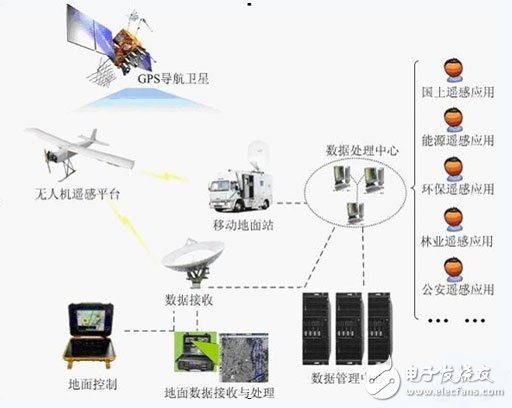
This project is based on UAV as a flight platform, using high-resolution CCD camera system to acquire remote sensing images, using aerial and ground control systems to achieve automatic image capture and acquisition, while achieving track planning and monitoring, information data compression and automatic Transmission, image pre-processing and other functions can be widely used in national ecological environmental protection, mineral resources exploration, marine environmental monitoring, land use survey, water resources development, crop growth monitoring and estimation, agricultural operations, natural disaster monitoring and assessment, urban planning And municipal management, forest pest and disease protection and monitoring, public safety, national defense, digital earth and other fields.
The project is mainly used for the acquisition of remote sensing images. At the same time, it can be matched with satellite remote sensing and man-machine remote sensing platform to achieve high and low collocation and complementary advantages. Low-altitude aerial photography of drones is widely used in national basic map mapping, digital city construction, communication station construction, land resources survey, land cadastral management, urban planning, real-time monitoring of emergencies, disaster prediction and assessment, urban traffic, network cable laying, Digital agriculture, surveying and mapping, environmental governance, ecological protection, forest management, mineral development and other fields have important practical significance for the development of the national economy.
Third, the company's board
1. Project content
The variety of on-board video images requires an encoder with high processing power and flexibility. Based on the CCD sensor + DM6467 intelligent video processing kit manual, widely used in intelligent monitoring, electronic police, video conferencing, biological instruments, machine vision and other fields. The platform mainly collects images through CCD sensors, performs signal processing through DSP, obtains intelligent information, and performs image compression and capture. This provides alarm information and on-site sampling for a variety of applications.
The CCD sensor mainly uses the sony ICX274AL chip.

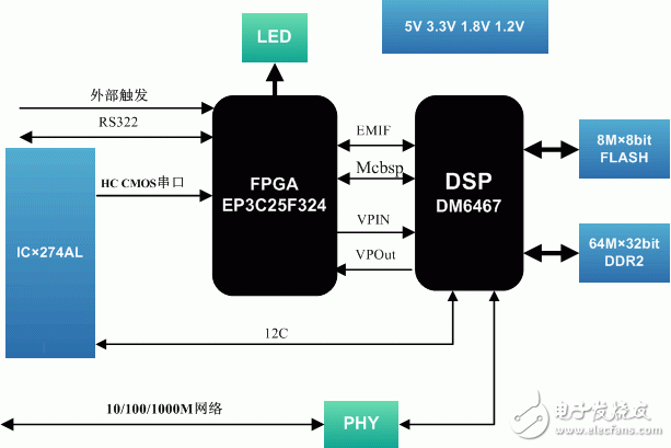
The TI chip TMS320DM6467, TI's next-generation HD video processing chip, can achieve up to ten times better performance than previous generation digital media processors through its multi-core design. The DM6467 processor integrates the ARM and DSP cores with HD video/image coprocessor (HD-VICP), video data conversion engine, and target video port interface. HD-VICP delivers more than 3 GHz of DSP processing power through dedicated accelerators for HD 1080i H.264 high profile transcoding, while the video data conversion engine manages downscaling and chroma sampling. ) and video processing tasks such as menu overlay (menu overlay). The DSP core can be used to manage multi-format video transcoding and reserve enough space to support other application performance. The DM6467 can meet the market requirements of media gateways and MCUs that require transcoding technology, but its flexibility and efficiency are also very attractive for applications that require high-definition encoding and decoding at the same time, such as video voice or video security. For markets with high requirements for multi-channel SD encoding. The device's connectivity peripherals also include industry-standard PCI buses and Gigabit Ethernet.
2, basic functions
The development of the hardware platform based on this chip is the core content of this project. The main functions are as follows:
1) The camera structure is a custom size, the size is 100mm X 70mm X 56mm
2) The system adopts DSP+FPGA as the core structure, the DSP is TMS320DM6467 and the main frequency is 729MHz, and the FPGA is Altera chip EP3C25F324.
3) Support one-way high-definition CCD 2 million pixel raw data stream input interface.
4) Support one-way Gigabit network transmission, which is RJ45 electrical port.
5) Support 1 channel RS232 communication, compatible with RS485.
6) Support automatic aperture, automatic electronic shutter function, adapt to different monitoring environments
7) Working voltage: voltage / DC 12V, power consumption is less than 5W.
8) Environmental conditions: Operating temperature: -20 ° C ~ +60 ° C; storage temperature: -45 ° C ~ +65 ° C;
Relative humidity: <=95±3%, +35±3°C;
9) Vibration and shock requirements are:
Vibration: 2g (20Hz ~ 500Hz ~ 20Hz) (rigid);
Impact: vertical axis ≥ 15g;
The horizontal axis direction is ≥10g;
Vertical axis direction ≥10g
3, software support
1) Support linux operating system
2) Support H.264 video compression, Jpeg image compression.
3) Support HD and CIF dual stream output
4) Support RTCP UDP data transmission of the network.
5) Support client test procedures.
6) Foundations You can embed other algorithms for your needs.
4, the scope of application:
It can be used for secondary development and use of face recognition, license plate recognition, behavior recognition, machine vision, production line testing, biological instruments, and medical instruments.
Fourth, product examples
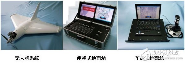
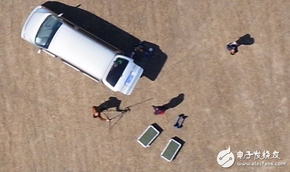
The UAV system realizes air patrol by configuring cameras, high-resolution cameras, infrared night vision devices and image transmission tasks, and returns video images in real time during the patrol, storing high-definition photos for return to the ground, in which infrared night vision The configuration of the instrument meets the requirements of night inspections.
Aerial photography:
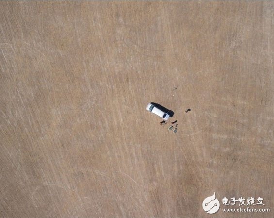
Actual proportion partial map:
The advantage of entertainment tablet lies in having a powerful chip and excellent hardware. If you want to play various online videos on the tablet and run various software smoothly, the performance of the hardware is an absolute prerequisite. In addition, a high-speed and stable WIFI module is also required, which must be compatible with multiple 802.11 B/G/N protocols at the same time, so that the webpage can be loaded instantly when the webpage is opened, and the online video can be played smoothly. So hardware is the premise and foundation, without good performance everything else is empty talk.
In addition to having a good CPU as a prerequisite, it is equally important to carry a professional video player. A professional video player must perform equally well both online and offline.
Entertainment Tablet,High capacity battery Tablet,WIFI Tablet
Jingjiang Gisen Technology Co.,Ltd , https://www.jsgisentec.com